Tonight I felt like saying a few comments about the way South Korean mapping services blur sensitive areas from their online satellite imagery.
You know that the Korean government mandates that certain sensitive areas (military bases, industrial centers, etc.) be blurred from online maps. But in my opinion, the way they go about this is not ideal. So I wanted to take a quick look at 3 examples of this blurring and give some quick comments on it. So let's bring on my favorite past-time: taking screenshots of maps.
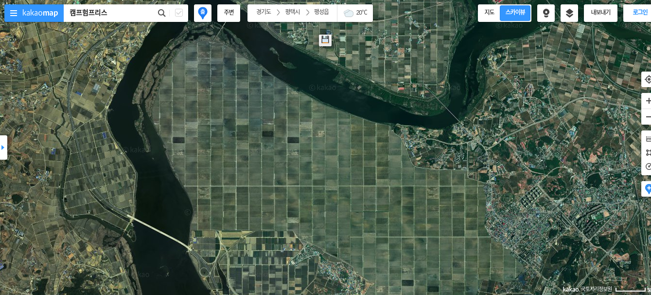
Let's start with some satellite views of the Camp Humphreys installation down in Pyeongtaek, by 5 different mapping sources.
I was curious to see where exactly the base is located since I've been down to Pyeongtaek a few times but never saw the base itself. And with all the news this year of the relocation from Yongsan, I went map surfing.
To start, let's look it up on my preferred map these days, Kakao Map:
Just a bunch of empty fields down there. You wouldn't know it from this imagery, but that area is not in fact a bunch of farm fields, but a sprawling and mostly developed military base.
Now let's take a look in Naver Maps:
Oh, just the same basic empty fields. This must be a truthful, accurate view of the area since these two separate and rival map services seem to have the exact same set of farm fields here, right? Look at those 3 telltale darker rectangles in the same area. This must really be just farmland, right? Where's the base?
Let's try an American service like the actually decent but underutilized mapping provider Bing. They wouldn't lie to us, would they?
The same dark squares! This has got to be an accurate view of the area. Weird that the city butts up against there but this whole peninsula is just agriculture land. But 3 separate map services can't be wrong. Right?
OK let's try Google. Last chance.
Oh. And there it is. America's largest overseas military base suddenly appears from out of the rural countryside. Google doesn't care about censoring these locations, which I find slightly odd since they apparently censor other locations though their idea of censoring is usually just falling back on lower-resolution imagery.
Of course none of this stops normal people from going ahead and providing all the details they want about this place in a publicly accessible way. Users have graciously labeled even individual buildings and location within Camp Humphreys over on Wikimapia, including something called the "Old Elephant Cage Antenna Array" which is a great name.
Overall I'm a little surprised that Bing would censor these locations since presumably they don't necessarily have to follow those censorship rules, but Bing also enforces mandatory "safe search" in South Korea regardless of your personal country settings (Google does this if your location is set to Korea, but changing to US / English allows you to choose your own level of strictness).
But what I'm much more surprised about is that all 3 of those providers seem to somehow have the same template laid over the land. Is that somehow provided by the government?
By the way, if you're curious to see what life is like inside this base, have a look at this article:
Home away from home - a guided tour of US military base in Pyeongtaek
Or watch this video:
Now here is my opinion on this map blurring and censoring issue: I really hate this this.
Here is why. I don't actually care about the censorship itself. I care about them using these fake farmland templates to cover it up.
Because I've been known to enjoy getting my ass up now and then and checking out the local scenery when I find myself on an overnight trip to various parts of Korea. And one way I like to do that is dragging myself up a mountain. Many major trails are clearly labeled on apps like Luga but plenty more are not. So I usually fire up a map on my phone, switch to satellite view, and take a gander at the local area looking for some spots that look like they'd make for a good walk or hike. This usually works out fine, but more than once or twice I've gone out of my way to get to an area that looks like this ("Wow! Nice smooth farm land right alongside a river. Let me take my bike out there...") only to get bummed out when the place is barb wired up with military warning signs.
Is any actual level of security gained from disguising it as farmland instead of say just a big blackout? After all, you can literally search for these places in the normal maps view. It's not like these installations are secret locations nobody's sure about. I understand wanting to hide the layout details from prying eyes. But disguising it as land other than what it really is seems to me like a good way to inconvenience people without gaining any security. If it were just plain blacked out, at least I'd know it's not a place that's any of my business. Or just a plain green with "Imagery removed" or something. Anything to just indicate it's an off-limits area instead of a place that looks inviting for a nice jog (not that I'm a jogger at all).
Here is an example that demonstrates a type of censorship that's just extreme blurring of the place that results in a cartoon like effect. All these screenshots here are of one district in the Asan National Industrial Complex.
So for example, let's say you're visiting Pyeongtaek and want to visit the sea-side. Open up your Kakao Map. Hey this looks like a nice forested hiking area right by the sea. Would be a great place to visit, right?
Don't get your boots out yet. Zoom in a bit.
Wait, what is this place? It's clearly not the dense forest area it seemed like. Some kind of natural type thing on the right (a golf course?) but those are some massive tanks at the end. Still, we don't know any information about this place; the imagery is completely unlabeled.
Let's switch over to Naver.
Ah ha. So now we know that this is part of the 원정지구국가산업단지 and therefore probably not a good place to go try to stroll around.
We actually get the shipping docks in this scene but still it's pretty blurry to really make anything out. Those tanks up there seem to belong to SP Tanks for storing chemicals/gas from shipping.
Maybe Google can clear things up for us:
Yes. Google maps once again gives us the clearest view of the area, uncensored.
That wasn't too bad an example since at least we could get an idea of what's there after zooming in. But the next example is the kind that grinds my gears.
The Daesan Petrochemical Complex is a massive industrial-chemical area that hosts LG, Hyundai, and other major refineries and manufacturers.
But you wouldn't know that from looking at Korea's online mapping services.
Take a look at what this area looks like on Kakao Map. Notice here that the entire area, no matter your zoom level, appears to be beautiful forest land right along the coast. You'd be forgiven for thinking it's some kind of natural park. Another great place to get some nice seaside hiking in, right?
You get the idea now. Let's switch to Google to get a more honest look.
That's what this area really looks like. Clearly not the kind of place you should try to access by climbing up over a ridge in your hooded North Face windbreaker.
What really gets my goat here though is that when you zoom in to this massive petrochemical industrial area on a service like Kakao, you can literally see hiking trails cut into the forest. Take a look at this close-up shot.
See those lines cutting through the forest? Exactly the same type of imagery you would find on real mountain forest trails around Korea. The imagery is probably copy/pasted from another area that actually hosts hiking trails. You might be tempted to visit the area and look for a signpost or an entrance up the mountain.
But remember: there is no mountain here. There are no trees. There is no trail. This is all fake cover. Here is the exact same spot zoomed-in on Google Maps:
I don't want to seem like a dumbass, but I have fallen for this exact trick more than once. Because checking the satellite view 8 out of 10 times gives me a good idea of where hikers have broken ground for trails that are likely to be marked, but just aren't labeled on Naver Map or Luga. And in a place like Korea, chances are no matter where you live you aren't more than a 10 or 20 minute walk from some kind of established trails.
Again, I'd appreciate it if this whole area were just blacked out, or pixelated beyond recognition. Someway to be sure that it's not a place worth exploring. As it is, it can be confusing for tourists or ourdoors types unfamiliar with the area, regardless of whether you're Korean or foreign.
The same "fake mountain forest" type of covering is used to censor the U.S.'s Osan Air Base.

Don't try hiking that mountain. It doesn't exist.
One last example. This is actually what I would personally prefer as a default censorship tactic for these locations. The GM Automotive factory down in Changwon is also censored on domestic map portals, but it is done by blurring the actual map imagery. To me this is the best mix of security (I have no real idea about the layout or structure of the facility) and convenience (I know whatever is there is not for me).
Update: Here's another example I came across. I noticed in an article by the newspaper Hankyoreh that they included a full clarity aerial photo of this minor US military base (with a more storied history going way back to Japanese occupation times) in Incheon. Yet the base, a "sensitive" area, is still blurred on Naver Map.
The purpose of this post is really just a warning or a reminder to others who (like me) might enjoy exploring off the beaten path of Korea. The recommended touristy places are fine but there's a lot to be said for seeing the country just by setting out and wandering around for the day. I've found plenty of great little hole in the wall restaurants and funny conversations with locals usually just by picking a place on the map and seeing what's there.
Just be aware that areas on the map that look good might not necessarily be that way. If you see an area that looks good, I recommend you try a few things first:
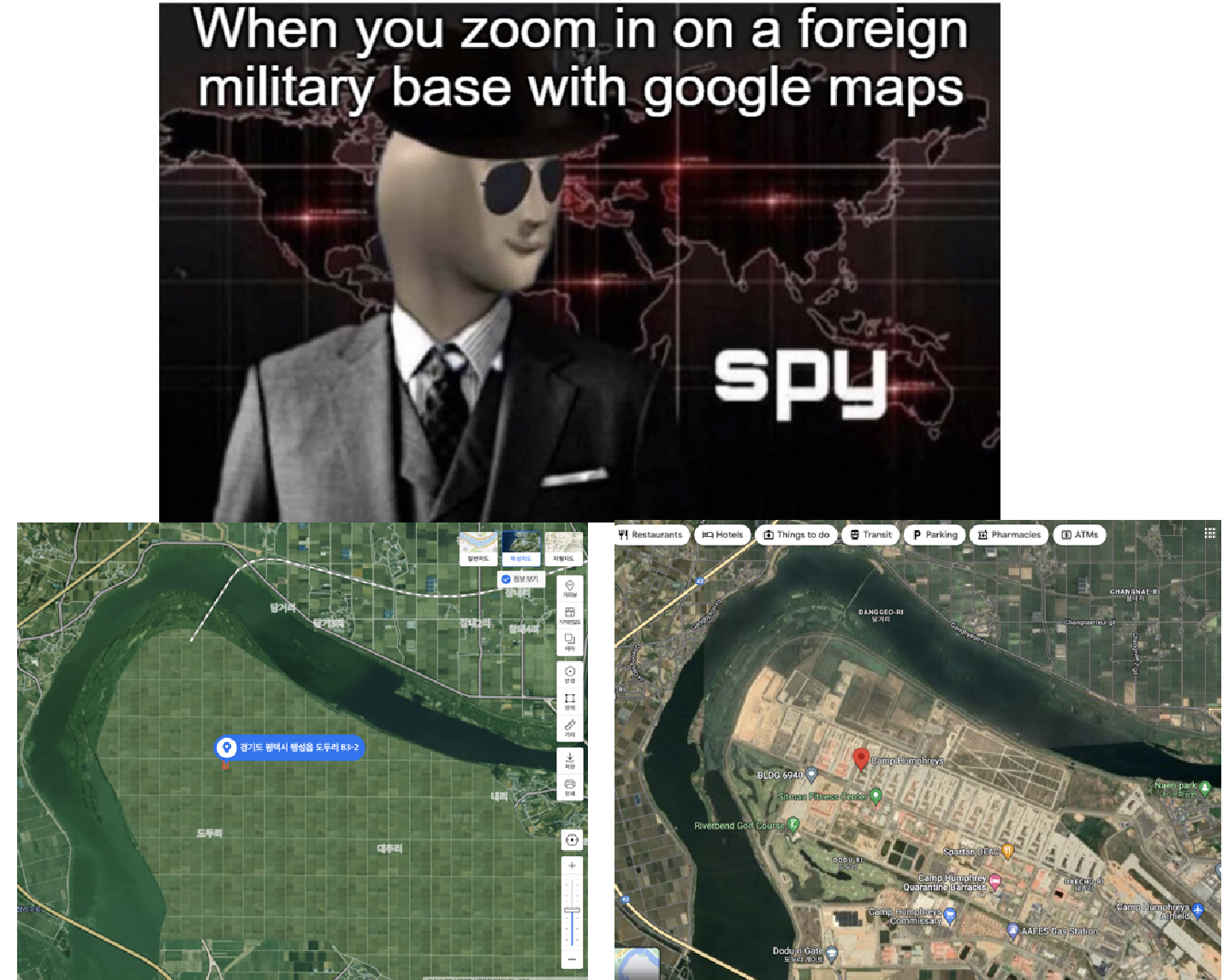
Update: an amusing image associated with this topic. Originally from r/memes. Sometimes switching from Naver Map to Google Maps feels like this.
You know that the Korean government mandates that certain sensitive areas (military bases, industrial centers, etc.) be blurred from online maps. But in my opinion, the way they go about this is not ideal. So I wanted to take a quick look at 3 examples of this blurring and give some quick comments on it. So let's bring on my favorite past-time: taking screenshots of maps.
Comparisons of map censorship techniques in South Korea
 |
| Same location, Naver Map satellite view vs. Google Maps satellite view |
Camp Humphreys
Let's start with some satellite views of the Camp Humphreys installation down in Pyeongtaek, by 5 different mapping sources.
I was curious to see where exactly the base is located since I've been down to Pyeongtaek a few times but never saw the base itself. And with all the news this year of the relocation from Yongsan, I went map surfing.
To start, let's look it up on my preferred map these days, Kakao Map:
 |
| Screenshot: Kakao Map |
Just a bunch of empty fields down there. You wouldn't know it from this imagery, but that area is not in fact a bunch of farm fields, but a sprawling and mostly developed military base.
Now let's take a look in Naver Maps:
 |
| Screenshot: Naver Map |
Oh, just the same basic empty fields. This must be a truthful, accurate view of the area since these two separate and rival map services seem to have the exact same set of farm fields here, right? Look at those 3 telltale darker rectangles in the same area. This must really be just farmland, right? Where's the base?
Let's try an American service like the actually decent but underutilized mapping provider Bing. They wouldn't lie to us, would they?
 |
| Screenshot: Bing Maps |
The same dark squares! This has got to be an accurate view of the area. Weird that the city butts up against there but this whole peninsula is just agriculture land. But 3 separate map services can't be wrong. Right?
OK let's try Google. Last chance.
 |
| Screenshot: Google Maps |
Oh. And there it is. America's largest overseas military base suddenly appears from out of the rural countryside. Google doesn't care about censoring these locations, which I find slightly odd since they apparently censor other locations though their idea of censoring is usually just falling back on lower-resolution imagery.
Of course none of this stops normal people from going ahead and providing all the details they want about this place in a publicly accessible way. Users have graciously labeled even individual buildings and location within Camp Humphreys over on Wikimapia, including something called the "Old Elephant Cage Antenna Array" which is a great name.
 |
| Screenshot: Wikimapia |
Overall I'm a little surprised that Bing would censor these locations since presumably they don't necessarily have to follow those censorship rules, but Bing also enforces mandatory "safe search" in South Korea regardless of your personal country settings (Google does this if your location is set to Korea, but changing to US / English allows you to choose your own level of strictness).
But what I'm much more surprised about is that all 3 of those providers seem to somehow have the same template laid over the land. Is that somehow provided by the government?
By the way, if you're curious to see what life is like inside this base, have a look at this article:
Home away from home - a guided tour of US military base in Pyeongtaek
Or watch this video:
Why this bothers me
Now here is my opinion on this map blurring and censoring issue: I really hate this this.
Here is why. I don't actually care about the censorship itself. I care about them using these fake farmland templates to cover it up.
Because I've been known to enjoy getting my ass up now and then and checking out the local scenery when I find myself on an overnight trip to various parts of Korea. And one way I like to do that is dragging myself up a mountain. Many major trails are clearly labeled on apps like Luga but plenty more are not. So I usually fire up a map on my phone, switch to satellite view, and take a gander at the local area looking for some spots that look like they'd make for a good walk or hike. This usually works out fine, but more than once or twice I've gone out of my way to get to an area that looks like this ("Wow! Nice smooth farm land right alongside a river. Let me take my bike out there...") only to get bummed out when the place is barb wired up with military warning signs.
Is any actual level of security gained from disguising it as farmland instead of say just a big blackout? After all, you can literally search for these places in the normal maps view. It's not like these installations are secret locations nobody's sure about. I understand wanting to hide the layout details from prying eyes. But disguising it as land other than what it really is seems to me like a good way to inconvenience people without gaining any security. If it were just plain blacked out, at least I'd know it's not a place that's any of my business. Or just a plain green with "Imagery removed" or something. Anything to just indicate it's an off-limits area instead of a place that looks inviting for a nice jog (not that I'm a jogger at all).
Asan Industrial Complex
Here is an example that demonstrates a type of censorship that's just extreme blurring of the place that results in a cartoon like effect. All these screenshots here are of one district in the Asan National Industrial Complex.
So for example, let's say you're visiting Pyeongtaek and want to visit the sea-side. Open up your Kakao Map. Hey this looks like a nice forested hiking area right by the sea. Would be a great place to visit, right?
 |
| Screenshot: Kakao Map |
Don't get your boots out yet. Zoom in a bit.
 |
| Screenshot: Kakao Map |
Wait, what is this place? It's clearly not the dense forest area it seemed like. Some kind of natural type thing on the right (a golf course?) but those are some massive tanks at the end. Still, we don't know any information about this place; the imagery is completely unlabeled.
Let's switch over to Naver.
 |
| Screenshot: Naver Map |
Ah ha. So now we know that this is part of the 원정지구국가산업단지 and therefore probably not a good place to go try to stroll around.
We actually get the shipping docks in this scene but still it's pretty blurry to really make anything out. Those tanks up there seem to belong to SP Tanks for storing chemicals/gas from shipping.
Maybe Google can clear things up for us:
 |
| Screenshot: Google Map |
Yes. Google maps once again gives us the clearest view of the area, uncensored.
That wasn't too bad an example since at least we could get an idea of what's there after zooming in. But the next example is the kind that grinds my gears.
Daesan Complex
The Daesan Petrochemical Complex is a massive industrial-chemical area that hosts LG, Hyundai, and other major refineries and manufacturers.
But you wouldn't know that from looking at Korea's online mapping services.
Take a look at what this area looks like on Kakao Map. Notice here that the entire area, no matter your zoom level, appears to be beautiful forest land right along the coast. You'd be forgiven for thinking it's some kind of natural park. Another great place to get some nice seaside hiking in, right?
 |
| Screenshot: Kakao Map |
You get the idea now. Let's switch to Google to get a more honest look.
 |
| Screenshot: Google Maps |
That's what this area really looks like. Clearly not the kind of place you should try to access by climbing up over a ridge in your hooded North Face windbreaker.
What really gets my goat here though is that when you zoom in to this massive petrochemical industrial area on a service like Kakao, you can literally see hiking trails cut into the forest. Take a look at this close-up shot.
 |
| Screenshot: Kakao Maps |
See those lines cutting through the forest? Exactly the same type of imagery you would find on real mountain forest trails around Korea. The imagery is probably copy/pasted from another area that actually hosts hiking trails. You might be tempted to visit the area and look for a signpost or an entrance up the mountain.
But remember: there is no mountain here. There are no trees. There is no trail. This is all fake cover. Here is the exact same spot zoomed-in on Google Maps:
 |
| Screenshot: Google Maps |
I don't want to seem like a dumbass, but I have fallen for this exact trick more than once. Because checking the satellite view 8 out of 10 times gives me a good idea of where hikers have broken ground for trails that are likely to be marked, but just aren't labeled on Naver Map or Luga. And in a place like Korea, chances are no matter where you live you aren't more than a 10 or 20 minute walk from some kind of established trails.
Again, I'd appreciate it if this whole area were just blacked out, or pixelated beyond recognition. Someway to be sure that it's not a place worth exploring. As it is, it can be confusing for tourists or ourdoors types unfamiliar with the area, regardless of whether you're Korean or foreign.
Osan Air Base
The same "fake mountain forest" type of covering is used to censor the U.S.'s Osan Air Base.

Don't try hiking that mountain. It doesn't exist.
Changwon GM factory
One last example. This is actually what I would personally prefer as a default censorship tactic for these locations. The GM Automotive factory down in Changwon is also censored on domestic map portals, but it is done by blurring the actual map imagery. To me this is the best mix of security (I have no real idea about the layout or structure of the facility) and convenience (I know whatever is there is not for me).
 |
| Screeshot: Naver Map |
 |
| Screenshot: Kakao Map |
 |
| Screenshot: Google Map |
Bonus: Camp Market
Update: Here's another example I came across. I noticed in an article by the newspaper Hankyoreh that they included a full clarity aerial photo of this minor US military base (with a more storied history going way back to Japanese occupation times) in Incheon. Yet the base, a "sensitive" area, is still blurred on Naver Map.
 |
| Camp Market, Incheon, images via Naver Map (L) and Hankyoreh news (R) |
Final Thoughts
The purpose of this post is really just a warning or a reminder to others who (like me) might enjoy exploring off the beaten path of Korea. The recommended touristy places are fine but there's a lot to be said for seeing the country just by setting out and wandering around for the day. I've found plenty of great little hole in the wall restaurants and funny conversations with locals usually just by picking a place on the map and seeing what's there.
Just be aware that areas on the map that look good might not necessarily be that way. If you see an area that looks good, I recommend you try a few things first:
- Check a GPS activity aggregator like Strava. It can help you find local areas where hikers/joggers/cyclists tend to go. If your map area has very little Strava data, there's a good chance there's a reason for that. Locals know where the great outdoorsy spots are; you're not going to be a pioneer and find a little slice of local paradise all your own. Trust the Strava tracks, and be weary if the location has none.
- Check street view. Both Naver and Kakao offer street view imagery. If your curiosity area is suspiciously missing street view, that could just mean it's a mountain area. But if the roads leading up to it have blurred out imagery (like on the road to Camp Humphreys), you know it's a place you're not meant to see.
- Check Google Maps. Obviously. As I've tried to show, you get a clear view even if the imagery is a bit outdated or imperfect.
- Search the area first. Are there any locations listed nearby? Search them and see if any tourist type or outdoorsy things come up. If it's a nice place, there's a 99% chance locals or native tourists have already blogged about it.
Have fun, keep exploring the maps, but just be aware that this type of fake greenery overlay exists. Don't let it ruin your day out. Otherwise you'll get crotchety and spend a Sunday evening blogging about it.
Update: an amusing image associated with this topic. Originally from r/memes. Sometimes switching from Naver Map to Google Maps feels like this.
Comments
Notice though that the lat/long coordinates of the URL will get auto converted to some kind of X-Y numbering system that seems to correspond to the Kakao map imagery table so that the above URL will auto redirect to https://map.kakao.com/?urlX=495118.0&urlY=1129657.0